Atlas# 18 Area of Town: Westside
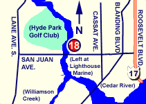
5434 San Juan Avenue (Map It)
Curtis Lee Johnson Boat Ramp is located on Cedar River. The ramp is well constructed, and able to handle all trailerable boats. Parking is limited for this busy ramp, and some users park off site and are picked up further on the River where parking at other areas is available. This is only one of two Westside ramps.
Click here to link to the NOAA website for weather conditions and tide reports.
|
  |
DRIVING DIRECTIONS:
From I-10 Downtown: 1. Take the exit, exit number 58, on the left towards US-17
S/ROOSEVELT BLVD.
2. Merge onto ROOSEVELT EXWY.
3. ROOSEVELT EXWY becomes ROOSEVELT BLVD.
4. Turn RIGHT onto SAN JUAN AVE/FL-128.
5. Ramp in on left side before crossing bridge. |
 |
| PROVIDES ACCESS TO: |
NUMBER OF TRAILER PARKING SPACES: |
| Cedar River |
15 |
| OVERFLOW PARKING: |
DOCKING AND STAGING: |
| Not readily available |
floating docks |
| ADA ACCESSIBLE: |
HOURS OF OPERATION: |
| Yes |
24 hours/7 days |
| NUMBER OF RAMP LANES: |
AMENITIES: |
| 2 |
Restrooms |
| COORDINATES: |
|
| N 30° 16.916' W 81° 44.398' |
|
| SPECIAL CONDITIONS: |
VESSEL USE RATING: |
| Limited parking |
A= (unlimited) |
| VESSEL USE RATING GUIDE |
A= unlimited;
B= vessels less than 22 Feet |
C = jon boats and jet skis;
D= hand launch only |
|